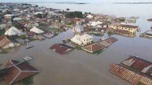

The Nigeria Hydrological Services Agency (NiHSA) has forecasted severe flooding across 29 states and the Federal Capital Territory (FCT) from September 1 to 15, 2025.
The alert, issued yesterday, highlights 107 local government areas (LGAs) at risk, with 631 communities directly threatened by potential inundation.
This development builds on the agency’s earlier 2025 Annual Flood Outlook (AFO), released in April, which had already flagged widespread vulnerabilities nationwide.
The advisory, signed by NiHSA Director-General Mr. Umar Mohammed, is grounded in real-time hydrometric data, river-stage projections, and satellite imagery, emphasizing moderate to very high risk levels.
Potential hazards include river overbanking, flash floods, and localized flooding in riverine and low-lying regions, which could disrupt critical infrastructure such as highways, bridges, and public facilities.
The agency warns of broader implications, including threats to lives, livelihoods, agriculture, and heightened risks of water contamination and disease outbreaks.
Affected states encompass a broad swath of the country: Adamawa, Akwa Ibom, Anambra, Bauchi, Bayelsa, Benue, Borno, Cross River, Delta, Ebonyi, Edo, Gombe, Imo, Jigawa, Kaduna, Kebbi, Kogi, Kwara, Lagos, Nasarawa, Niger, Ogun, Ondo, Plateau, Rivers, Sokoto, Taraba, Yobe, and Zamfara, in addition to the FCT.
Over 50 key transport and infrastructure points are also vulnerable, potentially exacerbating economic disruptions in these areas.
This September alert aligns with the broader 2025 AFO, unveiled on April 10, 2025, by Minister of Water Resources and Sanitation, Engr. Prof. Joseph Terlumun Utsev, in Abuja.
Themed “Flood Resilience: Focusing on Communities Preparedness and Adaptation Strategies for Flood Management,” the annual report had initially identified 1,249 communities in 176 LGAs across up to 33 states and the FCT as high-risk zones, with an additional 2,187 communities in 293 LGAs facing moderate risks.
The forecast segmented risks by season: 657 communities in 52 LGAs at high risk from April to June; 544 communities in 142 LGAs from July to September; and 484 communities in 56 LGAs from October to November.
Urban centers like Abuja, Lagos, Port Harcourt, Ibadan, Kano, and Makurdi, along with coastal states such as Bayelsa, Delta, and Rivers, were flagged for flash, urban, and sea-level-induced flooding.
NiHSA’s enhanced methodology for 2025 incorporates advanced hydrological modeling, remote sensing, and AI-driven predictions, marking a shift to community-based forecasting for more targeted warnings.
Director-General Mohammed emphasized the role of inter-agency collaboration and technological advancements in providing actionable insights for sectors like health, education, agriculture, and infrastructure.
“We are transforming flood data into real-time decisions and impactful resilience-building,” he stated during the April unveiling.
Click to signup for FREE news updates, latest information and hottest gists everyday
Advertise on NigerianEye.com to reach thousands of our daily users